Telestra Software
Terrain Effects
In the real world, terrain features can impact radio and tactical communications causing degradation or complete loss of signal. This is highly relevant on the battlefield, and translates to a desirable (and often necessary) training element, particularly for ground-based operators and vehicles.
Terrain Interface
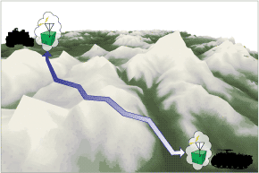
ASTi's Terrain Interface software applies occulting, ranging, and degradation effects to communication paths in the Telestra radio environment. The interface also allows a terrain server on the host network to specify pathloss due to local terrain.
Customers may use their own terrain databases or ASTi's Terrain Database server to query software along with the Terrain Interface to provide occulting and signal degradation information. The use of a database offloads the complete simulation of terrain effects from the communications environment including voice and tactical data transmissions, jamming, etc.
Terrain Interface capabilities include:
- Ability to choose between any combination of occulting, ranging and terrain effects.
- Set software to send out requests to a remote server for pathloss effects.
- Verify terrain propagation by viewing variables in the tuners.
Terrain Database
ASTi's Terrain Database server offloads occulting and signal degradation information and provides complete simulation of terrain effects on the communications environment including voice and tactical data transmissions, jamming, etc. For convenience, a complete DTED Level 0 dataset of the earth is delivered with the ability to install higher-fidelity terrain data in desired areas of interest.
The Terrain Server interacts with Telestra via the modeling environment's existing Terrain Interface and supports all transmitter/receiver pairs on the network.
Propagation algorithms are optimized to ensure real-time performance and handling of large amounts of transmitters and receivers, without sacrificing accuracy of the Fresnel Zone diffraction effects.
Terrain Database capabilities include:
- DTED Level 0 terrain data of complete earth
- Ability to add custom data on top of baseline data
- Optimized path loss calculation for real-time performance
- Fresnel Zone diffraction effects
- Tracking of all transmitters/receivers over the simulation network
- Visualization tool for point-to-point queries